Aworth News
Work at an aerodrome
June 17, 2021
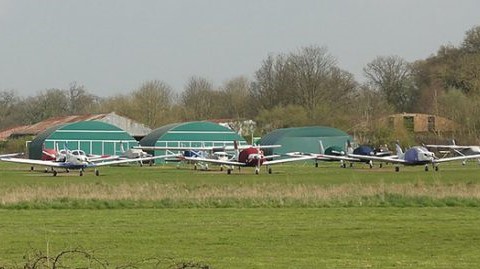
Over the years, we have been called in to survey many historical locations including Tooting Bec Lido, the RAC Club in Pall Mall and Covent Garden. More recently, we were asked to undertake a topographical and utility trace survey of Panshanger Aerodrome, near Welwyn Garden City in Hertfordshire.
Panshanger is a former general aviation aerodrome, which was used during the Second World War by the RAF for training purposes. After the war, it became a flying school and was, for a time, managed by De Havilland Aircraft. It eventually closed in September 2014.
There are plans to potentially build homes on this brownfield site, although there have been calls to maintain an airfield, alongside some new housing.
Today, the site is mainly flat and open grassland, with trees on the northern, eastern and western boundaries, with a housing estate to the south.
The purpose of the survey work we carried out was to accurately locate:
- On-site and off-site buildings
- Trees, hedges and bushes
- Fences, walls and boundaries
- Road markings, surfaces, pavements, services and street furniture
- Drainage – invert levels, sewer types, pipe sizes, direction of flow
- Electronic underground services trace survey (to identify telecommunication cables, drainage, and electricity cables etc)
We were also required to produce 3D Contours to show the model shape of the site.
Head Office
Norfolk House, Norfolk Way,
Uckfield, East Sussex TN22 1EP
T: 01825 768 319
London Office
The Lansdowne Building,
2 Landsdowne Road, Croydon CR9 2ER
Newsletter
Subscribe to our mailing list to keep in touch with all the latest news or follow us on:


![]()

© 2026 Aworth Survey Consultants. All rights reserved.
Site by: NWD