Laser Scanning
Laser Scanning
Architects, designers and engineers often require far more than just a 2D survey drawing to fulfil their building’s Lifecycle Management. Aworth Survey Consultants offers the complete BIM compliant survey service, tailored to our clients’ specific requirements.
If you need to take your project beyond AutoCAD 2D plans and drawings, Aworth Survey Consultants can provide data from 3D Laser Scanning and supply 3D point cloud data and Autodesk Revit modelling outputs to take your refurbishment, redevelopment or conservation project to the next level.
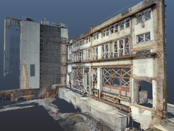
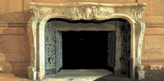
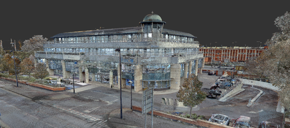
3D Laser Scanning is revolutionising digital data capture for 3D use. Across all industries 3D is becoming more common for design, presentation and engineering. Laser Scanning allows the real world environment to be captured in 3D exactly as it is.
The scanning process creates a point cloud made up of millions of dimensionally accurate 3D points. Colour in the form of an RGB value is also captured.
The point cloud can then be reconstructed to give it a surface and rendered with colour or images added to give a realistic texture to the 3D model. In addition, fly-through models can also be produced.
You can view, measure or mark-up rich, laser scan point clouds with the free Leica TruView local viewer, Autodesk ReCAP or in the Revit or AutoCAD environments.
Aworth Survey Consultants offers Autodesk Revit modelling to take your refurbishment, redevelopment or conservation project to the next level. If you are working towards a Level 2 BIM workflow a Revit model is a good start to a refurbishment or alteration project.
Aworth use the same core values to build accurate Revit models from pointcloud, total station data and hand measurement. We can also convert existing 2D AutoCAD projects into Revit.
Head Office
Norfolk House, Norfolk Way,
Uckfield, East Sussex TN22 1EP
T: 01825 768 319
London Office
The Lansdowne Building,
2 Landsdowne Road, Croydon CR9 2ER
Newsletter
Subscribe to our mailing list to keep in touch with all the latest news or follow us on:

![]()

© 2026 Aworth Survey Consultants. All rights reserved.
Site by: Networld Design